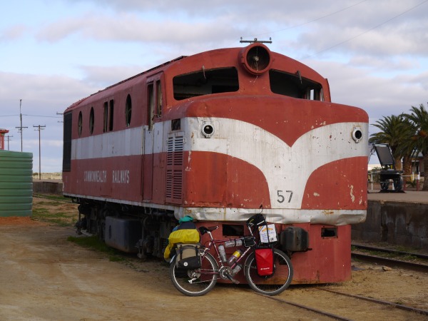
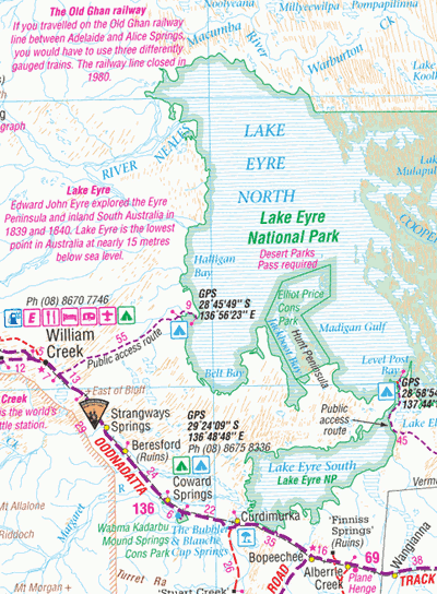
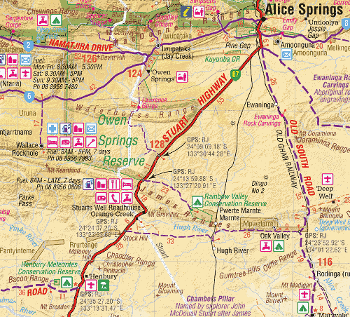
These are the track notes and details about cycling the Oodnadatta Track in July 2015, from Leigh Creek to Alice Springs, that I took while cycling it. This is not a complete guide. For a guide, check out GJ Coop Cycle Trails Australia website.
You can also find more details in this forum post where I give some advice to an aspiring outback-cyclist.
For the Oodnadatta Track you will find here my GPX file with useful waypoints from 2015 (things may have changed since, so be cautious)
Quick journey guide (South to North)
- Leigh Creek: Foodland/IGA, everything you need, campsite has nice rooms ($20), but very hard to pitch a tent on a campsite
- Farina: campsite is $5 per person, hot showers, toilets, water, quite popular. Bakery! Yes! Historic bakery, runs from May to July, very good bread and pastry! Not much left at the end of the day though, better to camp there and get fresh stuff in the morning.
- Marree: free campground behind hotel, coin showers (hot), food at the pub is very small for the price :(
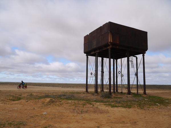
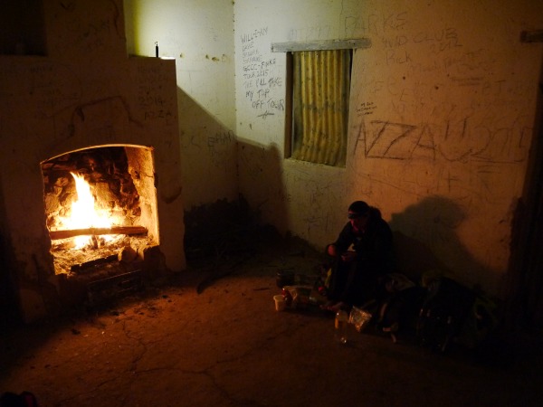
- Wangianna station ruins: most of the roof is still there, good shelter, fireplace, historic cyclingdutchgirl graffiti ^^
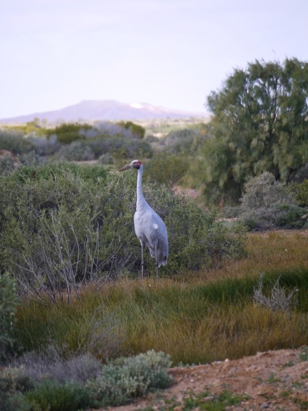
- Alberrie Creek (just after Muton park sculpture park) is a wild oasis as the bore water is flowing freely, it’s a beautiful place. We saw lots of birds there, including Sarus cranes! There is an abandoned campsite behind the abandoned hotel (a good shelter for camping as well), including flushing toilets and cold showers. The bore water flowing in the bathtub nearby is warm so it’s a good idea to collect it in a water container and shower with it :) Great place! I’m not sure if the water is good for drinking, probably a bit salty I think but not completely sure.
- Curdimurka has a water tank from bore water with a tap and an abandoned cottage. Same, not sure about water.
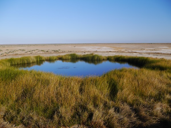
- Blanche Cup / The Bubbler springs, I think the water is not good for drinking and it’s only 6 km from Coward Springs, but a must-see short sidetrip
- Coward Springs has rain water tanks, bore water and a bore water spa, awesome, cheap camping, hot showers!
- Beresford ruins is an old train station, but can still provide shelter, has a nice fireplace and window holes were shut so good shelter from the wind, there’s a waterhole nearby
- Strangway Springs: another great side trip (2 km track but very corrugated), water in mound springs, not sure about water quality or taste
- there’s a broken bore water pipe somewhere between these two places, water was too salty to drink, but OK for cooking or washing dishes
- Irrapatana siding: just a few old walls, nothing else, lots of thorns in that area, check your tires, check under your tent before laying your mat, check under your feet if walking barefoot (nice red sand :) ), and check in your shoes, mine had a thorn in the morning, blown in from the wind, not a fun way to start the day :)
- William Creek: public toilets (there’s two of them, one is in a bad state, the other is better) have water but way too salty to drink. The pub has nice food, burger was $20. You can get water from the pub if they are in a good day. It took us about 10 minutes of talking to get some rainwater from them. There’s supposedly a bore somewhere else around but I think they said it was dry.
- Edward Creek: in the creek itself is a nice campsite near an old windmill, about 50-100 metres from there is a cattle trough filled with bore water. The water is OK to drink, just filter/boil it, or get it directly from the pressure tap inside the trough. The Edward Creek ruins (a bit further from the road) are in a sad state, most of the roof is gone, but if you needed some shelter it might do. But the creek is quite sheltered from the wind (the wind was horrible on that day, we cycled 22 km in 3 hours, with only 6 km the first hour and a half).
- Warrina ruins: no roof left
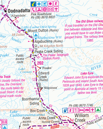
- Peake Creek: there was water, nice place, ruins have no roof
- Algebuckina waterhole: permanent waterhole, the station ruins are falling apart and have no roof, nice camping along the waterhole, impressive bridge. Yabbies can be fished in the waterhole.
- Oodnadatta: campsite ($22), hot showers, good food, washing machine, Optus coverage, decent foodshop, post office. Noisy place with music and dogs barking during the night.
- No1 bore (24 km from Oodnadatta): water OK to drink
- Mundarinna waterhole: nice enough but damaged by cattle, water
- No2 bore (52 km from Oodnadatta): water OK from cattle trough
- Boiler Hole Bore: cattle trough, water OK
- Marla: expensive food store, restaurant, $20 campsite, Telstra coverage, hot showers, noisy campsite (generator and roadtrains)
Mobile phone coverage
- Leigh creek: Telstra NextG
- Oodnadatta: optus 3G
- Marla: Telstra NextG
Not much else. Please note that when Telstra NextG coverage is advertised, but not “Telstra wholesale” it means that providers using the Telstra “3G” network won’t work, only Telstra SIM cards will work.
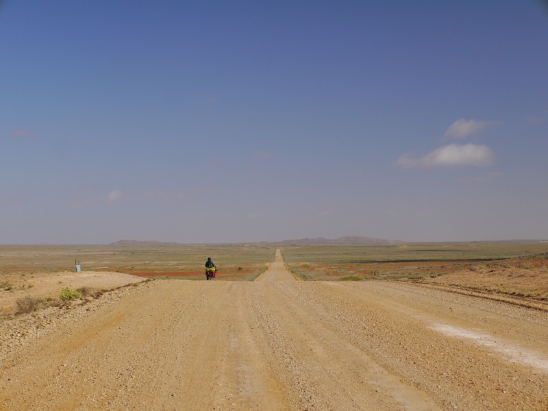
Leigh creek to Marree
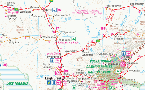
Good road. Sealed from Leigh Creek to 2 km North of Lyndhurst, then 17 km after Farina, then the last 8 km to Marree. Good unsealed road.
Leigh Creek has a good small supermarket (Foodland) open mon-fri and sat morning. Meals at Liz open cut cafe (same hours as foodland, good and cheap, $8.50 lot burger) and tavern (quite good, meals are $15). Internet access at community library (free). Caravan park $8 pp unpowered or backpacker bed $20. Nice and clean with fully furnished and closed camp kitchen with couches. Good Telstra nextG coverage.
(Please note that in 2016 the Leigh Creek mine closed down, and shops may have closed or hours may have changed.)
Lyndhurst has toilets, water, picnic tables, a small roadhouse, and is the turn-off to the Strecklzeki track
Farina has a campground ($5 pp) with donkey hot showers, flush toilets, tables, wood barbecues, bore water (drinkable), nice and sheltered campsites. It even has a working bakery from May to July ($6 bread, sweets and other stuff $2 to $4). Historic ruins.
Marree has a free campground back of the Marree hotel with grass spot for tents. Toilets and hot showers. $2 per shower (honesty box). Undrinkable bore water. Rain water available from tank between the tennis court and the picnic tables, near the public toilets. Other tanks are padlocked. Water casks $8 for 10 litres from the hotel (?). Meals at the hotel ($18 to $34 for mains), small plates, still hungry, not very good. General store.
Marree to Coward Springs
Road is sometimes good, mostly fine, and sometimes bumpy but still ok to ride.
Wangianna is an old fettlers cottage ruins. Shelter from the wind. Fireplace.
Alberrie creek is where the Mutonia sculpture park lives (make sure to visit it, just on the side of the road). Abandoned cottage with kitchen and wood cooker, available as shelter (some chairs and tables). Free (?) abandoned campground with flush toilets and cold showers (white buildings after the cottage, near the dog sculpture). Warm water available from the free flowing bore. Or donkey shower in the small shed before the cottage. Almost drinkable bore water from the toilets tap. Some rainwater in the small tank behind the cottage.
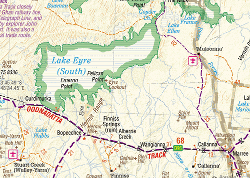
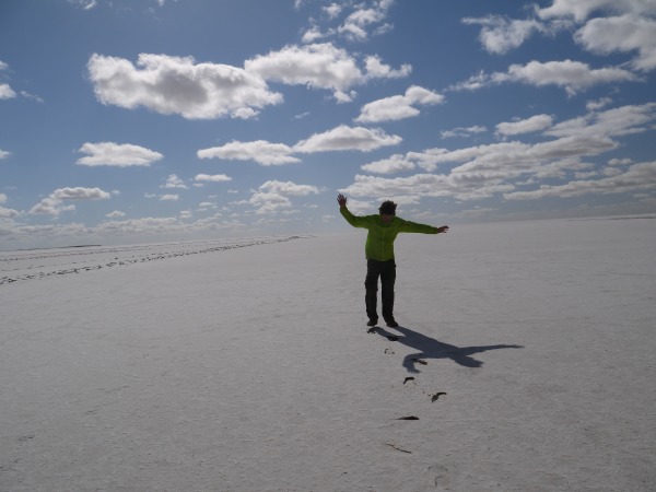
Lake Eyre South: great view from the information bay or from the road. Can walk on the lake from the information bay (too far at other points), be warned it can be very muddy, not a good idea to try to ride there. Don’t walk barefoot, the salt will hurt your feet!
Curdimurka siding: shelter (old cottage), fireplace, bore water (may need to open the tap at the bore water tank).
Blanche Cup / the bubbler: beautiful mound springs. Lunar landscape. 5 km from the road. Access track is a bit corrugated in places and at a point might need to ride through some puddles.
Coward springs campground with “natural” spa (29°C), very relaxing. Beautiful place, friendly people (for sale). Day use $2 pp, camping $12.50 pp. Toilets, donkey hot showers (campers only), spa, local museum. No firewood collection (need to bring your own firewood, not so easy with a bike). Rain water tanks, bore water. Really a nice place.
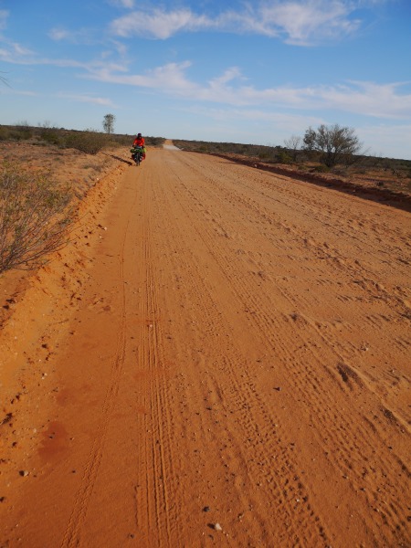
Coward springs to William Creek
Road is mostly bad. Corrugated and rocky. Bumpy. Have to ride on the wrong side of the road most of the time. Side road to strangway springs is worse and sandy.
Beresford ruins: old fettlers cottage, abandoned, like wangiana, but in better shape. Fireplaces, basic shelter, sheltered campsites. No water, just bore pool for cattle.
Strangway springs: nice walk (mound springs walk) with some mound springs, very special place. Water from the springs is salty. Sidetrack to carpark 2 km from the road. Sandy and corrugated. Carpark can be a nice campsite.
Irrapatana siding: ruins, no roof, no shelter, no camping (fence). Area is full of thorns, be careful.
William Creek: hotel/pub ($20 to $25 mains for lunch, good and large ration), campground ($12.50 single or $24 double, generator noise). Public toilets with bore water (salty, not suitable for drinking). No public rainwater tank. If asking nicely at the pub, maybe some barmaid will be nice enough to give you some rainwater. But officially the pub sells bottled water if you ask them. A couple of bores in the area, but quality and access is not known.
William Creek to Oodnadatta
Road is quite good at the beginning for the first 60 km and Duff creek, the turn-off for Nilpinna HS (where there was a road work team). Then not so good again, some corrugation, some rocky/bumpy parts. Very hard work if head winds. Not straight at all, some hills. Road is mostly impassable after any kind of rain, with mud locking the wheels. Better wait a few hours or a day for it to dry up. Last 6 km to Oodnadatta is quite a nightmare with soft sand slowing you down just like if you were riding on a very thick carpet. Even worse when wet.
Duff Creek: bush campsite near the old ghan bridge. 66 km from william creek, at Nilpinna HS turn-off.
Edward creek: nice shaded campsite near the old windmill (slightly creaking) in the creek. Bore water (mostly drinkable) from the cattle trough on the right, just after the creek (next to rusted car). Ruins of fettlers cottages and houses a bit further, but in a terrible state (no roof), not really suitable for shelter unless desperate.
Warrina siding: ruins, no roof. Memorial plaque for the elder expedition that left from here.
Peake creek siding: ruins, no roof.
Algebuckina: cottage ruins, no roof, dangerous. Historical bridge 600m long. Permanent (huge) waterhole 1.3 km from the road with nice shaded campsite. No facilities, but water in the waterhole (and yabbies, sort of small prawns).
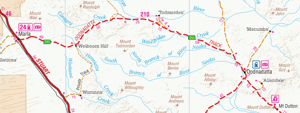
Mt Dutton siding: cottage ruins, no roof (didn’t check, seemed like it from the road), windmill nearby, maybe bore water?
Oodnadatta: post office (mon-fri 9am-noon, sometimes the afternoon, after hours service at discretion of roadhouse staff), small store with basic supplies, a bit expensive ($5.50 bread, biscuits $4 for 500g, noodles $1), meals ($10-$25, good) and caravan park ($11 pp, somehow the campsite is a bit dirty and old but have mostly clean facilities, camp kitchen only has microwave, boiler and toaster. Laundry is $5+2.40 for dryer) at Pink roadhouse. Bore water is drinkable. Nice museum in the old railway station (key available at roadhouse for $10 deposit). Free camping at Northern end of town. Public toilets. Transcontinental hotel. General store has closed, use the roadhouse instead. Optus 3G coverage.
Oodnadatta to Marla
Road up to the Dalhousie Springs turn-off (18km) is the same as 6 km before Oodnadatta : would be a nightmare after any rain. Some soft sand patches. Then good riding for a while (flat), then some heavy corrugation and gravelly bumpy road and small hills. Lots of gibber plains, hard to pitch tent pegs, and lots of spiky thorny plants that will puncture tent floor and mattress.
No 1 bore: drinkable bore water in cattle trough, around 25 kms from Oodnadatta. Same at another bore, 70 kms from Oodnadatta. Another at around 90 km from Marla.
Marla: camp ground $10 pp, shitty camp kitchen (nothing, no chairs, dirty as hell), clean showers and toilets, nice lawn for tents, LOUD generator noise and passing road trains during the night, camping here not recommended unless you really need a shower. Bore water ok for drinking but slight mineral taste. Water caskets 10L for 7.50$. Very expensive small supermarket (bread 5.30$ biscuits $4 for 250g, noodles $2). Meals and takeaway food (meals $15-$25, takeaway $7-$10). Telstra nextG coverage, no Telstra wholesale coverage.
Marla to Alice Springs
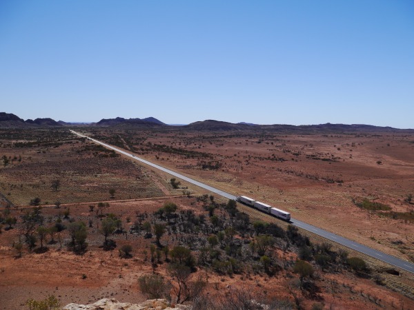
Bitumen road, intermittent shoulder.
Water at Marryat rest area (rain water tank), 39 km before the NT border, then big water tank (filled by trucks) at NT/SA border rest area.
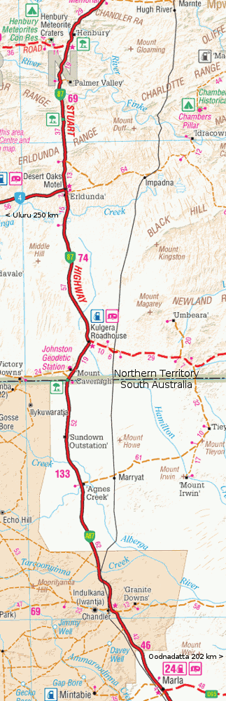
Kulgera: no phone coverage, no food, no water for drinking, only expensive and seriously small takeaway food, unfriendly staff. Campground $15 pp, loud generator noise. Water in toilets has heavy mineral taste.
Erldunda: Telstra NextG coverage. Very expensive food (more than in Marla: biscuits $6 for 250g, bread $5, chocolate $8.50, noodles $2.50), meals (not really good), camping (??$), bore water in toilets has heavy mineral taste, OK for cooking only.
Water tank (filled by trucks) at Desert Oaks rest area, 33 kms north of Erldunda. Drop toilets, tables.
Henbury meteorite craters = 15kms detour from the highway (11k on Giles rd), corrugated dirt road. Drop toilets, picnic tables and shelters, fire pits. Camping $3.30 per person (honesty box, bring cash). Short walk along the craters, but you can also climb the nearby Bacon Range ridge to get a better view across the craters (very nice).
Finke river rest area: toilets, water tank, picnic tables.
Stuarts Well roadhouse: toilets, campground, very little food. Expensive burgers, cheaper ones can be had at the camel farm just before the roadhouse.