Access
- Car: 2 hours (135 km) drive from Auckland CBD to the end of Kaueranga Valley Rd.
- Bicycle: train to Papakura train station, cycle 85 km to Thames (6-8 hrs), then 22 km along Kaueranga Valley Rd (gravel), lots of paid campsites along this road.
- Public transport: poor, you can take the bus (InterCity, Naked Bus, etc.) to Thames, but you will still have to do the 22 km of (mostly gravel) road to the start of the walk. You could hitch a ride, especially on Saturday mornings with all the people going there, or you could try to contact local tour companies, like CanyoNZ, they usually go there most days for canyoning and might be able to offer you a ride for a fee.
Day walk or overnight?
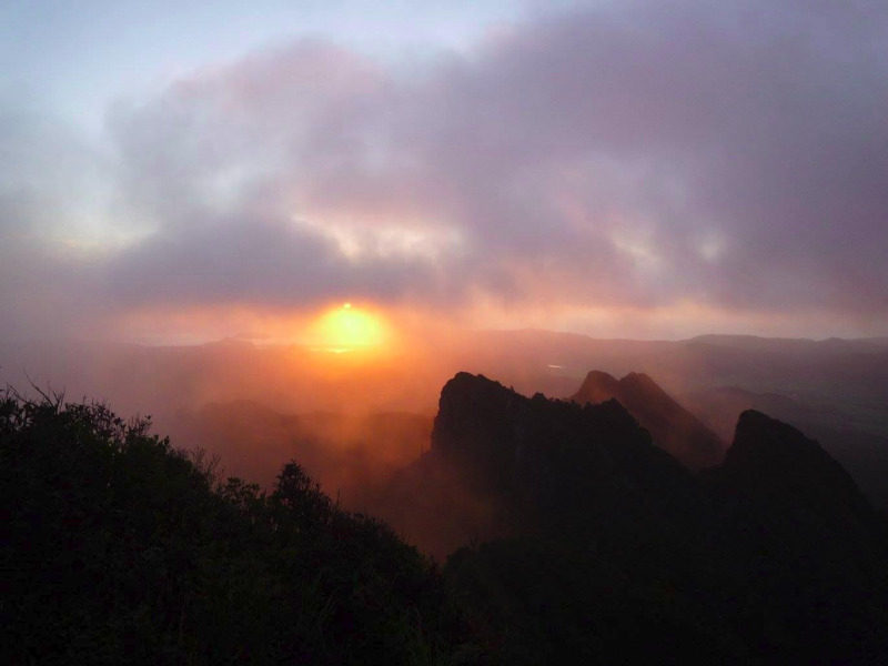
This hike is a popular overnighter but can also be done as one long day circuit (start early, there’s about 8 hrs of walking). But going to the summit of the Pinnacles at dawn or dusk to see the sunset or sunrise is definitely a highlight if the weather is fine. But you could also walk back down to the carpark at night with a good headlamp, the track down Webb Creek is well defined and easy to follow, but might be slippery, so care is advised (and a GPS in case you get lost).
Camping options
Booking is required to use the Pinnacles hut for the night ($15 per adult). The 80 beds hut (split into two dorms) is usually booked out one or two weeks ahead of every Saturday and long week-ends, as it is quite popular with Aucklanders as a week-end trip. So, if you can, prefer coming on a week day, or even a Friday or Sunday night to avoid the crowd. The hut has mattresses (bring you own sleeping bag), a cold shower, toilets, creek and rain water, and a common room with tables, gas cookers, sinks, and even some kitchen ustensils. This hut is the only one in New Zealand to have a warden every day of the year, so don’t count on not paying your night. If you haven’t booked and the hut is full you might have to turn back and walk at night to the carpark. If it’s not full you might have to pay up to three times the overnight fee, so make sure you have booked before going.
Another option is to camp at Dancing Dam campsite ($5 per adult), a short walk from the hut. This small campsite only has four sites that must also be booked beforehand.
Bookings can be made online on the DOC website with a credit/debit card or at i-SITES and DOC Visitor centres for a small fee.
Track
There’s a couple of parking options. The best one is probably leaving your car at the Billygoat walk carpark, after the Totara Flat campsite, about 500 metres before the carpark at the end of the Kaueranga Valley road. This is unsigned and small but usually less busy. Or you could go at the carpark at the end of the road, 500 metres further, and walk back.
From here clean your shoes and take the track to the river, less than a hundred metres from the road. You will have to cross the river to begin the walk. This is the only wet crossing of the walk, as the bridge has been destroyed by a flood in 2014. Be careful, even if the river is not too deep it might be flowing fast enough to make you fall and hurt yourself. If the river is too deep, too fast or you don’t feel confident enough to cross here, just go up the Webb Creek track instead (from the carpark at the end of the road). And obviously do not cross the river if it is in flood, brown, or if rocks or rumbling down. Read more on river crossing techniques.
Unstrap your pack belt, help yourself with a stick, a walking pole or a walking partner to cross the river, and meet with orange arrow markers on the other side to follow Billygoat Walk that is soon becoming steeper. Ignore the Tarawaere track and ontinue. Be careful as some sections are quite slippery in wet weather. The climb will let you get some rare views that will help you enjoy the effort.
After a while you will reach the Billygoat incline where old tramway tracks will guide you to a flatter part of the track and great views on the Billygoat Falls (also called the Sleeping God Canyon by local tour operators). One hour and a half later you reach an intersection where with a track leading to the Tarawaere track and to Broken Hills, this is a serious tramp. But today just take left on Billygoat Walk in the direction of Pinnacles Hut and Webb Creek track. You soon reach the Billygoat campsite, with a few tent sites and toilets. A good spot to rest or have lunch.
The track from now will undulate up and down and cross a few streams. In summer you can just rock hop to cross them, but if they are too deep just follow the signed Flood detours to use the bridges.
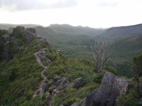
About an hour and a half later you will see an old hut on the left, and just after that you meet the Webb Creek Track at an old campsite. Take right and follow the track uphill to the hut. On the left side sadly a power line makes a ugly sight but on the right side great views soon appear.
After leaving your stuff at the hut follow the well defined track up to Pinnacles summit. A bit of climbing is in order, helped by a few ladders. Be careful at the summit and enjoy the great views.
Go back to the hut and on the next day just follow the Webb Creek track back down to the carpark, meeting a number of streams and suspension bridges, and a good amount of steps. At the end of the descent you will meet the junction with the Moss Creek track, a long, muddy and not-so-interesting alternative to join back Pinnacles Hut. From the carpark, walk down the road for 500 meters to find your car at the beginning of Billygoat walk.