This is a classic tramp in the Arthur’s Pass region with amazing views. It’s accessible to most people and has no perilous sections but you need to check the Cass river water level with DoC staff in Arthur’s Pass before going as you have to cross it several times. It follows a part of the Te Araroa trail and although some parts are classified as a route, it’s very easy to find your way. You’ll encounter four huts along the track so you can choose to walk it in two or three days depending on the time (and weather !) you dispose of and you’ll also find plenty of camping spots.
As this is a one way trip with about 15 km of road between its two ends, you’ll have to arrange transports or hitchhike back which is quite easy in summer. You can walk it in either direction but the one we propose is probably easier as you will climb down the steepest part.
Access
- Public transport : the TranzAlpine train operates daily all year round (except on Christmas day) from Greymouth to Christchurch, stopping at Arthur’s Pass. It’s still a further 30 km on SH73 to the start of this walk but as already said, it shouldn’t be too hard to hitchhike to the start of the walk. There is a train station station in Cass but it’s used only for freight.
- Bicycle: if using the TranzAlpine train you might have to book your bike beforehand, as they are limited to four per train. You then have to cycle 30 km on a good highway (but traffic is heavy in summer). Cycling on the tramping track is not allowed.
- By car : there is a carpark along the highway at the start of the track but it’s not safe to leave your car there overnight. Prefer parking in Cass settlement, at the railway carpark, only one kilometre from the start. There is also a carpark at the other end of the track (Cora Lynn road) which would be quite safe as there is a lodge not far from it.
Details
- Best time to go : from November to April. Due to the high danger of avalanche on Cass saddle, avoid it if there is snow on it. Ask the DoC visitor centre before going anyway especially to know if the Cass river is passable safely.
- Costs : Hamilton hut is a serviced hut ($15) and you can camp near it for $5. The four other huts (Cass Saddle, West Harper, Lagoon Saddle and Bealey huts) are basic and free to use.
- Time : you can do it in two days (staying overnight at Hamilton hut) or more leisurely in three (as described here) which also gives you more time to find a ride to or from the track.
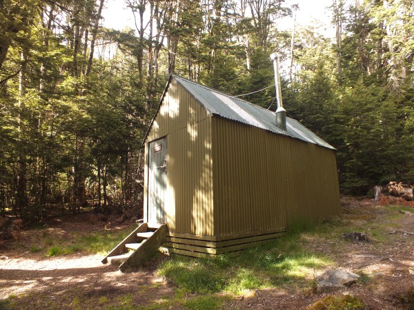
- Accommodation : as said before, you’ll pass four huts on your way. Cass Saddle hut has three bunks with mattresses and a fire stove. Hamilton is a 20 bunk hut, popular with The Araroa walkers and has a fire stove, mattresses, a radio and a nice view. West Harper hut has 5 bunks and a stove but no mattresses, is used mainly by hunters and has an authenticity like any of the other huts ! Lagoon Saddle hut is actually two huts : an A-frame shelter which can sleep up to 4 persons but has no mattresses and fire is strictly prohibited around it due to the risks to the environment. The other one is across a stream with two bunks and mattresses and you can make a fire outside in a pit. The last hut on the track is Bealey hut, just 5 minutes before the end with 6 bunks and mattresses and an outside fire pit.
- Water : shouldn’t be a problem as you’ll follow rivers almost the all time except on the descent from Lagoon saddle. There is no farm on the tops so the water should be drinkable but you might want to treat it anyway.
Day 1 : Cass settlement to Cass Saddle hut, 4 hours.
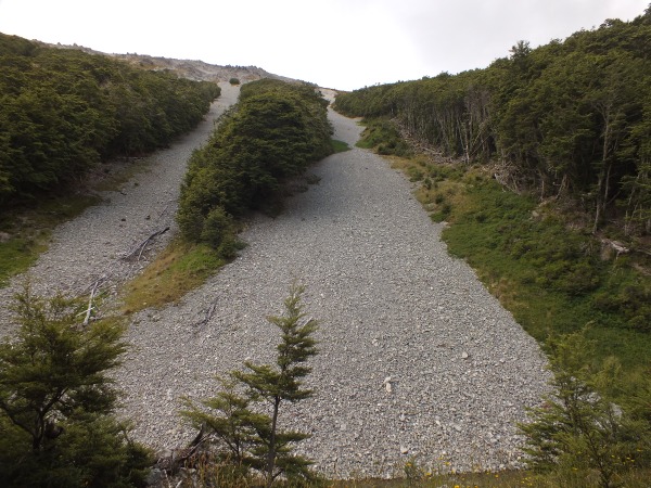
Start by walking one kilometre to the official start of the track, along SH73. You begin by walking on a vehicle track to Cass river that you then follow after crossing a barrier that marks the entrance into the Craigieburn Forest Park. There is no marked track at the beginning but it’s fairly easy as you just have to go upstream. It was very dry when we were there but we had to cross the river several times meaning wet feet. We didn’t encounter more than ankle deep water but once again, it was very uncommonly dry. Always check before crossing and be prepared to turn back if needed.
Try to stay on the true right of the river as that’s where the marked track that climbs into the forest starts. You leave the river bed to climb sometimes steeply but on a well defined track to a bridge, one kilometre before Cass Saddle hut, nestled in a small clearing. The hut is lovely and cosy but hang your food, mice are waiting for your noodles and chocolate ! There is a nice stove in which you can cook your bread if you feel like carrying flour with you and water flows just near the hut from a very pure and icy source.
Day 2 : Cass Saddle hut to Lagoon Saddle hut, 8 hours.
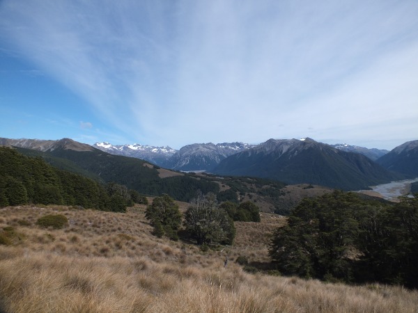
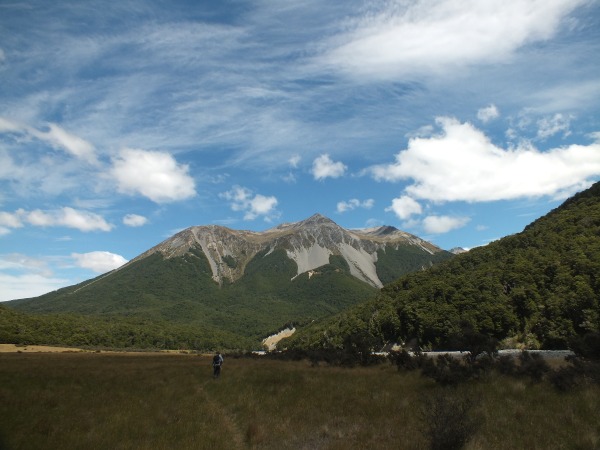
Cass saddle hut is just below the bushline so when you start climbing to the saddle itself (1326 metres high, 45 minutes from the hut), you have impressive views on the bare mountains around you.
Then you are going down into the forest to a beautiful valley with lots of possible camping spots. You need 2 hours from the saddle to reach Hamilton hut, following Hamilton Creek, at the end of the valley which gets a wonderful view and is very well maintained and is better insulated than many New Zealand’s houses ! Nice place to have lunch, away from the sandflies (or the rain !).
After the hut, you cross the Hamilton river on a newly installed swingbridge (previously a walkwire). You can do a 20 minute detour to Mirror lake, up a steep ridge although I don’t see how it got its name as the brownish water doesn’t reflect much…
Then you join the Te Araroa and follow the Harper river upstream (which means north, which means, for people who have no idea how you’re supposed to know where the north is, you turn right at the intersection after the swingbridge). You’re sometimes in the forest, sometimes along the river and it brings you to West Harper hut two hours after Hamilton hut. If the weather is fine, you can follow the river the whole time. Camping is possible around the hut and you can feel History when you step into the hut. Along with dust, mice poo and old trash. Very authentic but maybe not the best place to sleep if you don’t like sharing your bed with welcoming rodents.
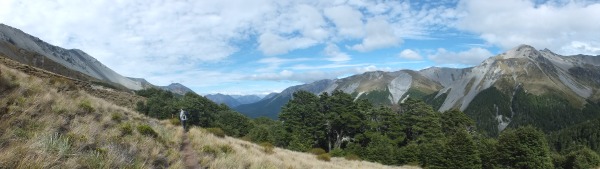
Lagoon saddle hut (1140 metres high) is 3 hours further, after a continuous climb in the forest. You can choose to stay in the old hut (mattresses and outside fire) or the A-frame shelter (no fire, no mattresses but mouse proof).
Day 3 : Lagoon Saddle hut to Cora Lynn carpark, 2h30.
You climb 30 minutes to Lagoon saddle where you have magnificent views on the snowy peaks and the valley. You then siddle around the slope of Mount Bruce, which could be quite muddy in places before reaching a pine forest where the track down is steeper but well defined and dryer. From the saddle, it’s two hours to Bealey hut and the end of the track. If you want to hitchhike, the highway is 10 minutes further.